Italien / Belluno - Cadini di Misurina
Hike around the Cadini group
Wanderung um die Cadini Gruppe
Cadini di Misurina (Ciadìs de Meśorìna in Ladin) is a group of mountains in the eastern Dolomites in the Province of Belluno, Italy. These mountains rise to the west of Auronzo di Cadore, north-east of Cortina d'Ampezzo and south of Dobbiaco, in a position overlooking Lake Misurina. They are part of the Dolomites subsection of Sesto, of Braies, and of Ampezzo, and belong to the municipality of Auronzo di Cadore. The highest peak is the Cima Cadin of San Lucano (2.839 m a.s.l.).
The term Cadini derives from the Cadorino dialect ''ciadìn'' which translates into valleys, and refers to the labyrinthian structure of the massif.
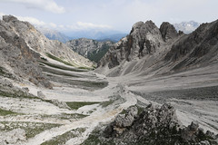
Description
The mountain range is crossed by the Alta Via n. 4 path and from the equipped Alberto Bonacossa path, which starts from the southern shore of the lake and reaches the Tre Cime di Lavaredo. The particular geomorphology that distinguishes and so deeply characterizes the Cadini di Misurina, however, allows to cross the group by various lines so that, going up and down from their forks, it becomes possible to enjoy the dolomitic paradise that surrounds them. The equipped path Giovanni Durissini allows for example to complete the complete tour of the branch of San Lucano. It is a ring route, starting at the Fonda-Savio refuge (2,367 m), which runs in sequence the Torre fork (2,400 m), the Sabbee fork (2,440 m), the Cadin Deserto fork (2,400 m), the Cristina fork, the de la Neve fork (2,471 m) and lastly the Nevaio fork (2,620 m), with a total height difference of about 1,000 m. The first climb dates back to 31 August 1896 by Giovanni Siorpaes, Pietro Siorpaes, Ilona Eötvös, Rolanda Eötvös, Johann Innerkofler, and Loránd Eötvös.
Accommodation facilities include refuge Fonda-Savio (2367 m), refuge Col da Varda (2115 m), and refuge Città di Carpi (2110 m).
Main summits
Cima Cadin di San Lucano, 2839 m
Cima Eötvös, 2825 m
Cima Cadin Nord Est, 2788 m
Cima Cadin della Neve, 2757 m
Cima Cadin Nord Ovest, 2726 m
Campanile Dülfer, 2706 m
Cima Cadin di Misurina, 2674 m
Torre del Diavolo, 2598 m
Torre Siorpaes, 2553 m
Torre Wundt, 2517 m
Cima Cadin di Rimbianco, 2404 m
Torre Leo, 2550 m
Punta Cadin de le Pere, 2550 m
Main passes
Forcella del Nevaio, 2620 m
Forcella Verzi, 2550 m
Forcella de la Neve, 2471 m
Forcella Sabbiosa, 2440 m
Forcella di Misurina, 2400 m
Forcella Cadin Deserto, 2400 m
Forcella della Torre, 2400 m
Forcella del Diavolo, 2380 m
Forcella Maraia, 2100 m
(Wikipedia)
Die Cadini di Misurina bilden als Untergruppe den südlichen Abschluss der Sextener Dolomiten und befinden sich in der Provinz Belluno in Italien. Die aufgrund zahlreicher spektakulärer Felsgipfel und Zinnen sehr eindrucksvolle Gebirgslandschaft wird im Westen vom Misurinasee, im Norden von den Drei Zinnen und im Süden und Osten vom Val d’Ansiei begrenzt und gilt als ein Paradies für Kletterer. Der höchste Berg ist die Cima Cadin di San Lucano (2839 m). Als Teil der von der UNESCO unter „Nördliche Dolomiten“ zusammengefassten Dolomitengruppen, gehört die Cadini-Gruppe mit allen Untergruppen seit dem 26. Juni 2009 zum UNESCO Welterbe Dolomiten.
Auf die Cima Cadin Nord Est (2796 m) führt ein sehr ausgesetzter Klettersteig, die Via Ferrata Merlone. Der Bonacossaweg (Sentiero Bonacossa) durchquert, teils ausgesetzt und versichert, unter Ausnützung von Felsbändern und alten Pfaden aus dem Gebirgskrieg, über mehrere Scharten die gesamte Berggruppe. Als lohnende Tour gilt auch die hochalpine Umrundung der zentralen Cadini-Gruppe (Giro di Cadini) auf dem Sentiero Durissini. Im Winter gilt dieser Weg als sehr anspruchsvolle Skitour.
Vom Misurinasee führt ein Sessellift zum Rifugio Col de Varda.
Weitere markante Gipfel
Cima Cadin di Rimbianco (2404 m)
Cima Eötvös (2837 m), benannt nach Roland von Eötvös
Berghütten in der Cadini-Gruppe
Fonda-Savio-Hütte (2359 m, CAI)
Rifugio Città di Carpi (2110 m, CAI)
Rifugio Col de Varda (2106 m, privat)
(Wikipedia)