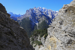
Italien / Belluno - Cristallogruppe
seen from Monte Piana
gesehen vom Monte Piana
Cristallo (Italian pronunciation: [kriˈstallo]) is a mountain massif in the Italian Dolomites, northeast of Cortina d'Ampezzo, in the province of Belluno, Veneto, northern Italy. It is a long, indented ridge with four summits higher than 3,000 metres. The mountain range is part of the "Natural Park of the Ampezzo Dolomites".
In the north of the Cristallo group is the 1,530 m high mountain pass "Cimabanche" (in German: "Im Gemärk" also "Gemärk Pass", in Ladin: "Sorabances"), in the south the mountain pass Tre Croci (1,809 m, in Ladin: "Son Zuógo").
Peaks
The highest peaks of the Cristallo massif are Monte Cristallo (3,221 m), Cima di Mezzo (3,154 m), Piz Popena (3,152 m) and Cristallino d'Ampezzo (3,008 m). Cima di Mezzo and Cristallino d'Ampezzo can be reached by via ferratas, while Monte Cristallo and Piz Popena both require climbing skills.
First climbs
Monte Cristallo (3,221 m): 1865 (Paul Grohmann, Angelo Dimai, Santo Siorpaes), 1874 (first woman: Anna Ploner)
Cima di Mezzo (3,154 m): 1881 (John Stafford Anderson, Santo Siorpaes, Giuseppe Ghedina)
Piz Popena (3,152 m): 1870 (Eduard R. Whitwell, Santo Siorpaes, Christian Lauener)
Cristallino d'Ampezzo (3,008 m): 1886 (Michael Innerkofler, A. Angerer)
Campanile Dibona, Monte Cristallo - west peak, (2,550 m - 8,370 ft), 1908 - solo Angelo Dibona
Geology
Cristallo is largely formed from the Upper Triassic dolomitic rock Dolomia principale. The mountain was formed during Cretaceous, as well as the rest of the Dolomites, due to the collision between the African and European continents.
Access
A cable lift system starts from Rio Gere in Val Begontina, first a lift to Rifugio Son Forca at the upper end of Val Padeon. The gondola lift up to Forcella Staunies (2,919 m), close to Rifugio G. Lorenzi (2,932 m), was built for the Winter Olympics in Cortina in 1956. Both the lift and the refuge closed in summer 2016 due to "technical and administrative problems".
The Dolomite Highway number 3 goes through the eastern part of the massif.
Via ferratas
The two via ferratas VF Ivano Dibona and VF Marino Bianchi both start from the top of the cable car at Forcella Staunies. VF Marino Bianchi can be followed to the peak Cima di Mezzo.
VF Ivano Dibona follows the Zurlon-ridge. It is a historical route used in World War I, and later restored and made safe for tourists. At the beginning is the longest via ferrata suspension bridge in the Dolomites, the 27-metre-long Ponte Cristallo.
The via ferrata VF Renato de Pol can be used for access from the western side of the Cristallo massif.
Winter sports
Cristallo is one of the major skiing areas in the surroundings of Cortina. The former Staunis Verticale slope is one of the steepest in the Alps. There are numerous freeride ski routes on Monte Cristallo. The very steep gullies of the Forcella Staunis are known. To the east of Monte Cristallo there is a small ski area at Lake Misurina.
Cabins (rifugi) and restaurants
Some of the cabins and restaurants available are the Rifugio Son Forca at 2,235 m; Capanna Guido Lorenzi at 3,003 m (Auronzo di Cadore); Ristorante Rio Gere at 1,680 m; Ristorante Lago Scin at 1,336 m; Ristorante Staulin at 1,370 m; Ristorante Son Zuogo at 1,800 m.
History
During World War I there was considerable military activity in the mountain. The front lines between Italian and Austro-Hungarian troops went through the mountains. Remains of ladders and barracks are still found today, and transport lines (ferratas) have been restored. At the passes Cimabanche and Tre Croci there are Italian bunkers from the time of World War II.
Popular culture
In 1993 the film Cliffhanger was shot on and around the bridge on the Zurlon-ridge, as well as some of the other peaks in the area. The mountain film The Blue Light from 1932 revolves around Monte Cristallo.
A legend narrates that on Monte Cristallo lived a beautiful princess who had many suitors, whom she always turned down.
(Wikipedia)
Monte Piana is a 2,324-metre (7,625 ft) tall mountain in the Sexten Dolomites and located on the border between the provinces of South Tyrol and Belluno. The smaller Northern summit of the mountain is named Monte Piano (2,305m).
During the so-called "White War" in World War I the mountain was hotly contested between the Austrian and Italian Armies. The Austrians had occupied the Northern summit Monte Piano, while the Southern summit Monte Piana was in Italian hands. Today many remnants of the fierce fighting can still be found on both summits.
History
When Italy declared war on Austria-Hungary on 24 May 1915, seven / eight battalions of the thirty-five stationed between San Candido and the Stelvio were sent to Monte Piana and its valleys. Monte Piana was part of the operational sector of the IV Army commanded by Lieutenant General Luigi Nava, whose units were divided into two sectors, Cordevole and Cadore, the first belonging to the IX Corps and the second, of which part of the sector of Monte Piana, under the jurisdiction of the 1st Army Corps commanded by Lieutenant General Ottavio Ragni. On 24 May the Piana was occupied by two platoons of Alpine troops of the 96th company, Pieve di Cadore battalion, of the 7th regiment. Other Alpini of the 67th company around 08:30 were hit by an artillery shell fired from Monte Rudo while they were working on the road from Misurina to Monte Piana; they were the first Italians to fall on a mountain that in less than two years made about 14,000 victims from both sides. Here, on 7 June 1915, second lieutenant Antonio De Toni (7th regiment, 268th company, batt. Val Piave) was fatally wounded, the first to be killed in the Padua university community.
At the end of the day, the two years of war on Mount Piana essentially led to nothing, the two contenders fought for two long years on a patch of land, without ever being able to subvert the enemy forces, and on 3 November 1917 the positions on the plain were abandoned by the Italian units to retreat and take sides on the Grappa line in an attempt to resist the Austro-Hungarian offensive in Caporetto
Between 1977 and 1981, on the initiative of the Austrian Colonel Walther Schaumann, the "Open-air Historical Museum of Monte Piana" was established and can be visited by all, free of charge. The works for the rearrangement of the trenches were carried out by the group "Friends of the Dolomites" (Dolomitenfreunde) with the reconstruction of the walkways, trenches, tunnels and stairways of the time. Every year since 1983, the restoration work of the trenches has been carried out during the first fifteen days of August, by the "Monte Piana Foundation" and the "Friends of the Dolomites" (who for the occasion formed the "Gruppo Volontari Amici del Piana" ")
In 1981, during the usual meeting on the first Sunday of September, dedicated to the commemoration of the fallen of Monte Piana, the "Friends of the Dolomites" handed over the open-air Historical Museum to the "Monte Piana Foundation", which then work area. In 1983, the newly established "Gruppo Volontari Amici del Piana" began its patient work of intervention on those elements that are damaged every year by bad weather and thaw.
Since that year, the volunteers are committed to faithfully reconstructing the sections of dry stone wall that collapsed during the winter; they recover what remains of the old shelters, restore the wooden structure and carry out a radical cleaning of the mountain from waste, in respect of the fact that this site has become a protected area. In addition, the access paths from the surrounding valleys are maintained and the relative signs are taken care of, currently assisted by retired colonel Elio Scarpa.
In 1986 the Group dedicated its name to the recently deceased vice president of the "Monte Piana Foundation", Elio Scarpa, who was thus given the credit for having made possible the launch of this initiative. But support for the work also came from the Italian army at the hands of the Alpine Troops Command, so the group of volunteers can use, during the work, an off-road vehicle, tents and various materials, in addition to valid help. of the military personnel placed at its disposal, for a collaboration that continues today,
(Wikipedia)
Die Cristallogruppe (italienisch Gruppo del Cristallo) ist eine Gebirgsgruppe in den Ampezzaner Dolomiten in Italien. Sie befindet sich zum überwiegenden Teil in der zur Region Venetien gehörenden Provinz Belluno. Ein kleinerer Teil im Nordosten der Gruppe gehört zu Südtirol. Als Teil der von der UNESCO unter „Nördliche Dolomiten“ zusammengefassten Dolomitengruppen, gehört die Cristallogruppe seit 2009 zum UNESCO-Welterbe Dolomiten.
Geographie
Lage
Die Gebirgsgruppe liegt nordöstlich von Cortina d’Ampezzo und südlich von Toblach zwischen dem Valle del Boite im Westen, dem Val d’Ansiei im Osten und dem nördlich der Gruppe verlaufenden Höhlensteintal. Höchster Gipfel ist der Monte Cristallo (dt.: Kristallberg) mit 3221 m s.l.m.
Abgrenzung
Die Gruppe wird im Südwesten von dem vom Passo Son Forca oder Son Forcia (2110 m) in nordwestlicher Richtung verlaufenden Val Padeon mit den Rio Bosco, einem linken Zufluss des Boite, von der Pomagagnongruppe abgegrenzt. Im Süden bildet der Passo Tre Croci (1809 m) der den Übergang zwischen dem Valle del Boite und dem Val d’Ansiei darstellt die Grenze zur südlich gelegenen Sorapissgruppe. Im Osten grenzt der Misurinasee (1756 m) mit dem Col Sant’Angelo die Gruppe von der Cadini-Gruppe ab. Im Nordosten bildet das obere Val Popena mit dem Rio Popena die Grenze zu dem den Drei Zinnen vorgelagerten Monte Piana, die zu den Sextner Dolomiten gehören. Im Norden bildet das in Südtirol gelegene obere Höhlensteintal mit Schluderbach (1438 m) und der westlich davon gelegenen Passhöhe Im Gemärk (1530 m) die Grenze zu den nördlich davon gelegenen Pragser Dolomiten mit der Plätzwiese im Osten und der westlich davon gelegenen Hohen Gaisl.
Administrativ teilt sich die Cristallogruppe auf die zwei Belluneser Gemeinden Cortina d’Ampezzo und Auronzo di Cadore sowie auf die Südtiroler Gemeinde Toblach auf.
Gliederung
Die Cristallogruppe ist nach SOIUSA eine Untergruppe der östlichen Ampezzaner Dolomiten. Sie wurde bereits zu Beginn des 20. Jahrhunderts als eigenständige Gruppe der Dolomiten betrachtet, so beispielsweise in dem von Antonio Berti verfassten und 1908 veröffentlichten Gebietsführer Dolomiti di Cadore, der 1928 erstmals in der vom Club Alpino Italiano herausgegebenen Reihe Guida dei Monti d’Italia unter dem Titel Dolomiti Orientali erschien.
Nach SOUISA und Berti lässt sich die Cristallogruppe in zwei Untergruppen aufgliedern, der Cristallo- und der Popenauntergruppe. Andere Autoren zählen als Untergruppe auch die westlich angrenzende Pomagagnongruppe dazu.
Gipfel
Monte Cristallo 3221 m
Cima di Mezzo 3154 m
Piz Popena 3152 m
Cristallino d’Ampezzo 3008 m
Cristallino di Misurina 2775 m
Tourismus
Schutzhütten
Rifugio Guido Lorenzi 2932 m, privat, seit 2016 geschlossen
Rifugio Son Forca 2235 m, privat
Ricovero Buffa di Perrero 2760 m, unbewirtschaftetes Biwak
Zugang
Durch das Massiv führt der Dolomiten-Höhenweg 3. Ein Sessellift führt von Rio Gere im Val Begontina zum (privaten) Rifugio Son Forca am oberen Ende des Val Padeon. Die Gondelbahn in die Forcella Staunies (2919 m) und zur Capanna G. Lorenzi wurde für die Olympischen Winterspiele in Cortina im Jahre 1956 errichtet; im Winter fungierte sie als Doppelsessellift, im Sommer als Stehgondelbahn. Seit 2016 ist sie bis auf Weiteres geschlossen.
Klettersteige
Drei Klettersteige (Via Ferrata) erschließen das Gebirgsmassiv und folgen zum größten Teil den alten Kriegspfaden. Neben der Via Ferrata Renato de Pol, die das Gebiet von Nordwesten her erschließt, gibt es noch die Via Ferrata Ivano Dibona und die Via Ferrata Marino Bianchi.
Geschichte
Während des Ersten Weltkrieges gab es hier erhebliche militärische Aktivitäten. Die Fronten zwischen den italienischen und österreichischen Truppen verliefen durch dieses Gebiet. Überreste von Leitern, militärischen Stellungen und Gebäuden zeugen noch heute davon.
Varia
Im Jahre 1993 wurden Teile des Filmes Cliffhanger – Nur die Starken überleben im Bereich der Cristallogruppe gedreht.
(Wikipedia)
Der Monte Piana ist ein 2.324 Meter hoher Berg in den Sextner Dolomiten an der Grenze zwischen den italienischen Provinzen Südtirol und Belluno, Italien, nördlich des Misurinasees. Der Plateauberg trägt noch den Monte Piano genannten Nordgipfel (2305 m). Der allein stehende Berg ist umgeben von den Drei Zinnen im Osten, der Cristallogruppe, der Cadini-Gruppe und dem Dürrenstein. Die Südtiroler Anteile des Bergs sind im Naturpark Drei Zinnen unter Schutz gestellt.
m Ersten Weltkrieg war der Berg zwischen Österreichern und Italienern heftig umkämpft (siehe dazu auch den Artikel Gebirgskrieg 1915–1918). Der Nordgipfel Monte Piano war von den Österreichern, der südliche Hauptgipfel von den Italienern besetzt. Auf dem hochplateauartigen Gipfelbereich zeugen die Stellungsanlagen, Schützengräben und Stollen beider Seiten, die sich teilweise nur wenige Meter gegenüberlagen, davon noch heute. Auf einem 1977 bis 1982 vom Verein der Dolomitenfreunde angelegten Historischen Rundweg können diese besichtigt werden.
Ein leichter Anstieg auf den Berg erfolgt vom Süden her zum Rifugio Angelo Bosi (2.205 m), bis zur Hütte als asphaltierte Fahrstraße. Die übrigen Auf- und Abstiege über den Touristensteig und den Pionierweg erfordern Trittsicherheit. Der Dolomiten-Höhenweg 3 überquert den Berg.
Zum Gedenken an die Rolle des Monte Piano als Kriegsschauplatz 1915–1917 wählte der Ausmusterungsjahrgang 2000 der Theresianischen Militärakademie in Wiener Neustadt den Namen „Jahrgang Monte Piano“.
(Wikipedia)