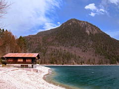
A shuttered wooden chalet at the lakefront of the Walchensee (in English: "Lake Walchen") in the Bavarian Alps, Bavaria, Germany
Some background information:
When we visited this place, the air pollution was rather severe. A lot of Saharan dust had reached southern Germany and that’s why the sky looks rather grainy and opaque in all my photos taken on that day. I remember having heard about Saharan dust reaching Germany for the first time about fifteen or twenty years ago. But I cannot remember Saharan dust having reached Germany already at the end of March. That’s much too early. For me the trend is quite disturbing and I summarize such trends under the heading "climate change". Obviously, we really have dealt ill with our planet. I fear for the future, actually.
Covering an area of 16.40 km², the Walchensee is one of the largest Alpine lakes in Germany. But with a depth of 189.5 meters, it is also one of Germany’s deepest Alpine lakes. The Walchensee is located about 80 kilometres (50 miles) to the south of Munich in the middle of the Bavarian Alps. The entire lake, including the island of Sassau, is situated within the municipality of Kochel am See (in English: "Kochel by the lake"). Both lake and island are owned by the Bavarian State.
The Walchensee occupies a tectonically induced valley, which is part of the Bavarian Syncline and consists of rocks from the upper Alpine Triassic (main dolomite, plate limestones, Koessen formations). The lake owes its depth of almost 190 meters to this tectonic origin. The northwestern rocky shore clearly exhibits the steep inclination of the rock layers towards the lake. Its formation by orogenic forces suggests that the Walchensee is one of the oldest lakes in Germany. During the Ice Ages, the morphology of the area, and consequently that of the Walchensee, was shaped multiple times by ice fields from the Isar-Loisach glacier.
The lake has one major tributary, the Obernach river, and two outflows, the Jachen river and the Walchensee Power Plant. The Walchensee lies at 802 metres (2,631 feet) above sea level. has a shoreline of approximately 27 kilometres (17 miles) and contains 1.3 cubic kilometres of water. It is surrounded by mountains, whereby the Benediktenwand mountain to the northeast of the lake is the highest, standing exactly 1,800 metres (5,906 feet) high.
The name "Walchen" has its origin in the Middle High German language and means "strangers". All Roman and romanized peoples of the Alps south of Bavaria were known to the locals as "Welsche" or even "Walche". This suggests that on maps of the 16th century, the lake was referred to as leading to Italy ("Italico dicto"). And italy was ancestral Roman homeland, resp. "Walchland".
There are a few settlements lakeside, of which the village of Walchensee, located directly on the west bank, is the largest. It has about 600 residents and is an officially recognised climatic health resort. However, all settlements lakeside belong to the municipality of Kochel am See. Other settlements include Urfeld, Zwergern and Einsiedel. Until the 18th century, the local population was so closely linked to the lake that it was customary to throw consecrated gold coins into the deepest part of the lake.
Between the Walchensee and its neighbouring lake, the Kochelsee, the Walchensee Power Plant can be visited. It is a a hydroelectric power station, which is already in operation since 1924 (with a few years of interruption). There’s even a visitor centre there and guided tours through the turbine hall can be booked. The power station uses the hydraulic head of about 200 m (660 feet) between the Walchensee (acting as the upper reservoir, at 802 metres resp. 2,631 feet above sea level) and the Kochelsee (acting as the lower reservoir, at 599 metres resp. 1,965 feet above sea level) to generate electricity. The installed capacity is 124 MW with an annual production of 300 GWh.
During World War II, a new Mach 10 wind tunnel was planned at the power station to develop Nazi Germany's planned A10 rocket. However, instead of a new wind tunnel and power plant, the Mach 4.4 wind tunnel used for V-2 rocket development was moved to the site, following the 1943 Operation Hydra bombing of Peenemünde. After the war, the Walchensee Power Plant was renewed and equipped with new turbines, while the wind tunnel was moved to White Oak, Maryland, in the US.
The commune of Kochel am See is a little town in the district of Bad Tölz-Wolfratshausen. It has almost 4,200 residents. The town is home to the Franz Marc Museum, which is dedicated to the famous German painter Franz Marc, who loved the area around Kochel and also bought a house there. The museum exhibits paintings from Franz Marc and other well-known expressionists (mainly from the artist circle "Blauer Reiter"), such as Wassily Kandinsky, August Macke. Ernst Ludwig Kirchner and Alexej von Jawlensky.
Apart from its scenery, the Kochelsee (in English: "Lake Kochel") and the Franz Marc Museum, the settlement is known for the Blacksmith of Kochel, who may be considered as a local folk hero. According to legend, he was a soldier in the army of the Holy League during the Great Turkish War. As the word is, he was only armed with a rod when he stood in front of the city gate of Belgrade. With his rod he rammed the gate and forced an entrance for his comrades-in-arms, so that Belgrade could be conquered in 1688.
Later, legend has it that the Blacksmith of Kochel led a Bavarian farmers' rebellion against the imperial troops of the Habsburg Emperor Joseph I during the War of the Spanish Succession. This rebellion culminated in the Sendlinger Mordweihnacht (in English: "Sendling Christmas Massacre") of 1705. In literature, the smith is described as a man of over 70 years of age, yet great in stature and power. For the revolt, he supposedly armed himself with a spiked club of his own making that weighed over 50 kg (100 pound) . In the night of the massacre, the smith fought in the ranks of the rebels at the Sendling Parish Church. There he died heroically, the last man to fall. Well, at least that's the legend.