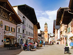
The Obermarkt (in English: "Upper Market") in the little town of Mittenwald with the parish church of St. Peter and Paul in the distance, Bavaria, Germany
Some background information:
When we visited this place, the air pollution was rather severe. A lot of Saharan dust had reached southern Germany and that’s why the sky looks rather grainy and opaque in all my photos taken on that day. I remember having heard about Saharan dust reaching Germany for the first time about fifteen or twenty years ago. But I cannot remember Saharan dust having reached Germany already at the end of March. That’s much too early. For me the trend is quite disturbing and I summarize such trends under the heading "climate change". Obviously, we really have dealt ill with our planet. I fear for the future, actually.
Mittenwald is a little market town in the Upper Bavarian district of Garmisch-Partenkirchen in the upper valley of the Isar river. It has about 7,250 residents and is located approximately 80 kilometers (50 miles) south of the city of Munich. The town lies between the Karwendel and Wetterstein mountain ranges in the Northern Limestone Alps (a part of the European Alps), directly on the border with Austria. Located at an altitude of 912 metres (2,992 feet) above sea level, Mittenwald is Germany's highest-altitude climatic health resort. Furthermore, the Mittenwald Karwendelbahn is the second-highest cable car in Germany.
In ancient times, the Roman road Via Raetia passed through Mittenwald, continuing over the mountain passes Seefelder Sattel and Brenner. In the 2nd century, it was fortificated. Connecting Augsburg (Augusta Vindelicum) and Bozen (Pons Drusi), it became the most important route through the Alps, surpassing even the Via Augusta. In the ancient Roman road map Tabula Peutingeriana, the road station Scarbia is mentioned, which was probably located in today‘s municipal territory of Mittenwald. Around 200 AD, the Romans called the Karwendel mountain range "mons nigris", meaning Black Mountain and its German name Schwarzenberg was still used until the Thirty Years' War.
The town, which was first mentioned in a document in 1096, originated from a clearing settlement in the Scharnitz forest. In 1305, it was granted market rights. Mittenwald’s surrounding forests were the basis for the flourishing timber rafting industry, where felled tree trunks were tied together to make huge rafts on the Isar, which were then drifted or pulled downriver. The raftsmen's guild in Mittenwald had 20 masters and numerous journeymen.
In the Middle Ages, Mittenwald belonged to the Prince-Bishopric of Freising. At that time, the town benefited from the well-organised trading network on the route from Nuremberg and Augsburg to Venice, as it was a significant trading post on that route. In the late Middle Ages, more precisely in 1487, the Bozen Market was relocated to Mittenwald by Sigismund, Archduke of Austria, from the House of Habsburg, who made this move due to the War with the Republic of Venice.
The Bozen Market was arranged in Mittenwald until 1679. Under these conditions, new industries such as braid weaving, silk embroidery, and violin making emerged until the end of the 17th century. Hence, many ouf the town’s residents achieved some affluence. In 1987, the tradition of the Bozen Market has been brought to life again. Since then, Mittenwald arranges a revived Bozen Market every five years in the form of a historic trade and craft market.
Noteworthy in particular is Mittenwald’s tradition of violin making. Since the second half of the 17th century, Mittenwald has developed into the most important center of string and plucked instrument making in Germany alongside Markneukirchen in Saxony. During his first trip to Italy, Johann Wolfgang von Goethe stayed overnight in the still-existing Goethehaus in 1786. Goethe called this place "a living picture book" and he did that for good reason as Mittenwald is famous for ist mural art, the so-called "Lüftlmalerei".
"Lüftlmalerei" is a popular, folk-oriented variation of trompe-l'œil from Baroque and imitates architectural elements. The name "Lüftlmalerei" derives from "Zum Lüftl", which was the name of the house of the 18th century façade artist Franz Seraph Zwinck. Zwinck did not come from Mittenwald, but from Oberammergau. However, "Lüftlmalerei" spread like wildfire in the villages and towns of southern Bavaria and Austria. Its subject matter ranged and still ranges from the patron saints of houses or house emblems to representations of Biblical stories and the classical motifs of peasant art from everyday rural life to hunting. Today, Mittenwald is renowned for being one of the focal points of "Lüftlmalerei" and visitors can find these murals on the façades of many houses.
But back to Mittenwald’s history: In 1805, Napoleon's soldiers were able to take the Leutasch Schanze via the so-called "Franzosensteig" with the help of the people of Mittenwald without significant losses. This path is now a popular hiking trail. With the opening of the Mittenwald railway station on the railway line between Garmisch-Partenkirchen and Innsbruck in 1912, tourism came to the town. In the 1930s, Mittenwald became a garrison and training center for the mountain troops of the Wehrmacht.
In April 1945, at the end of World War II, one of the "evacuation transports" from the Dachau concentration camp ended near Mittenwald. The memorial at the grounds of the primary and secondary school commemorates this event and the victims of war crimes committed by the mountain troops of the German Wehrmacht throughout Europe. From 1946 to 1952, a displacement camp was set up for Jewish and Ukrainian displaced persons.
Today, Mittenwald, along with the neighbouring villages of Krün and Wallgau, forms the tourism association "Alpenwelt Karwendel", which markets the region year-round as a starting point for sports and leisure activities such as hiking, mountaineering, climbing, as well as alpine skiing and cross-country skiing. The Dammkar in the Karwendel mountain range is Germany's longest ski slope, measuring 7.5 kilometers (4.7 miles).